![]()
|
Newspaper ArticlesSeptember 13, 1885 - In
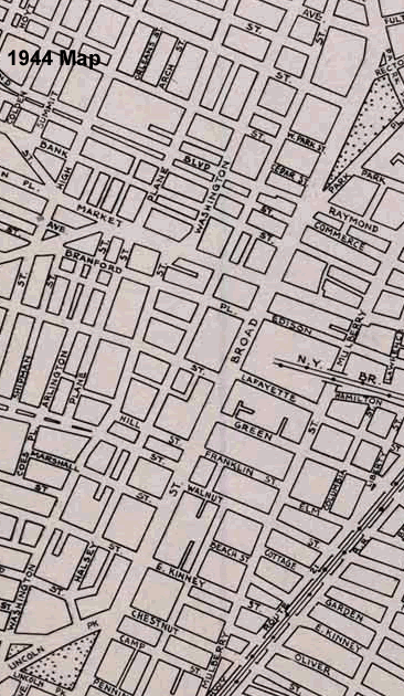
the Dead of Night Today Broad Street runs from Rafael Hernandex Elementary School south to the Route 21 Viaduct. At one time there were five streets with Broad Street in their names. Broad Street ran from Clay Street to Chestnut Street. South Broad Street was from Chestnut Street south. East Broad Street ran from Clay Street north. West Broad Street became Clinton Avenue in 1868. North Broad Street became Belleville Avenue (1868) and then Broadway. As were all Newark streets, Broad Street was orignally a dirt road that became muddy in the wet weather. In 1852 the street was finally paved with cobble stones. By 1887 the cobble stones were replaced with granite block, wood block was laid in 1914 and finally asphalt in 1926. From "A History of the City of Newark"
|
|||||||||||||||||||||||||||||||||||||||||||||||||||||||||||||||||||||||||||||||||||||||||||||||||||||||||||||||||||||||||||||||||||||||||||||||||||||||||||||||||||||||||||||||||||||||||||||||||||||||||||||||||||||||||||||||||||||||||||||||||||||||||||||||||||||||||||||||||||||||||||||||||||||||||||||||||||||||||||||||||||||||||||||||||||||||||||||||||||||||||||||||||||||||||||||||||||||||||||||||||||||||||||||||||||||||||||||||||||||||||||||||||||||||||||||||||||||||||||||||||||||||||||||||||||||||||||||||||||||||||||||||||||||||||||||||||||||||||||||||||||||||||||||||||||||||||||||||||||||||||||||||||||||||||||||||||||||||||||||||||||||||||||||||||||||||||||||||||||||||||||||||||||||
| Street | # | 1850 | 1860 | 1870 | 1880 | 1895 | 1905 | 1915 |
| Broad Street | 1-178 | North | ||||||
| Broad Street | 179-367 odd | East | ||||||
| Broad Street | 180-366 even | West | ||||||
| Broad Street | 368-724 | South | ||||||
| Broad Street | 1-19 | 8 | ||||||
| Broad Street | 20-176 | 1 | ||||||
| Broad Street | 178-366 even | 2 | ||||||
| Broad Street | 183-341 odd | 4 | ||||||
| Broad Street | 368-724 even | 3 | ||||||
| Broad Street | 343-723 odd | 9 | ||||||
| Broad Street | 1-378 | 8 | ||||||
| Broad Street | 379-633 | 1 | ||||||
| Broad Street | 635-873 odd | 2 | ||||||
| Broad Street | 634-856 even | 4 | ||||||
| Broad Street | 875-1253 odd | 3 | ||||||
| Broad Street | 858-1282 even | 9 | ||||||
| Broad Street | 1-378 | 8 | ||||||
| Broad Street | 379-633 | 1 | ||||||
| Broad Street | 635-873 odd | 2 | ||||||
| Broad Street | 722-856 even | 4 | ||||||
| Broad Street | 875-1035 odd | 3 | ||||||
| Broad Street | 858-1294 even | 9 | ||||||
| Broad Street | 1037-1301 odd | 14 | ||||||
| Broad Street | 1-162 | 8 | 8 | |||||
| Broad Street | 163-633 | 1 | 1 | |||||
| Broad Street | 634-1034 even | 4 | 4 | |||||
| Broad Street | 635-1035 odd | 2 | 2 | |||||
| Broad Street | 1036-end | 9 | 9 | |||||
| Broad Street | 1-162 | 8 | ||||||
| Broad Street | 163-409 odd | 1 | ||||||
| Broad Street | 164-348 even | 1 | ||||||
| Broad Street | 411-1035 odd | 2 | ||||||
| Broad Street | 350-1046 even | 4 | ||||||
| Broad Street | 1037-1253 odd | 9 | ||||||
| Broad Street | 1048-1250 even | 9 |
Enumerations Districts
| Year | # | Enumeration District |
| 1880 | 20, 21, 22, 23, 24, 25, 26, 29, 30, 33, 34, 35, 50, 51, 54, 57, 58, 59, 84, 85 | |
| 1900 | 1, 2, 3, 4, 5, 8, 9, 10, 12, 18, 19, 20, 34, 37, 38, 39, 40, 74, 80, 81, 82, 83, 84, 87 |
1869 Number Changes
| Before 1869 | After 1869 | |||
| Left | Right | Intersecting Street/Building | Left | Right |
| East Broad Street | Harvey Street | 2 | 1 | |
| Oriental Street | 60 | 59 | ||
| Third Avenue | 108 | 107 | ||
| Fourth Avenue | 164 | 163 | ||
| Gouverneur Street | 220 | 219 | ||
| Clark Street | 270 | 269 | ||
| Belleville Avenue | 331 | |||
| 1 | 2 | Stone Bridge | 344 | 343 |
| 5 | 4 | Clay Street | 348 | 349 |
| 19 | 18 | EighthAvenue | 378 | 379 |
| 34 | House of Prayer Episcopal Church | 399 | ||
| Grant Street | 402 | |||
| 36 | State Street | 409 | ||
| 38 | Plane Street | 411 | ||
| 49 | Cross Street | 426 | ||
| Green Alley | 438 | |||
| 53 | 58 | M & E RR Avenue Depot | 438 | 437 |
| 61 | M & E RR Avenue Division | 446 | ||
| 79 | 80 | Orange Street | 466 | 467 |
| 105 | Bridge Street | 498 | ||
| 105 | Third Reformed Dutch (North) Church | 510 | ||
| 108 | Washington Street | 499 | ||
| Washington Park | ||||
| 147 | Lombardy Street | 546 | ||
| 108 | Washingon Place | 559 | ||
| 161 | Fulton Street | 570 | ||
| 174 | Nesbitt Street | 577 | ||
| 181 | Rector Street | 598 | ||
| Military Park | Park Place | Military Park | ||
| Military Park | Trinity Episcopal Church | Military Park | ||
| Military Park | New Street | Military Park | 633 | |
| Military Park | West Park | Military Park | 677 | |
| Military Park | Cedar Street | Military Park | 705 | |
| Military Park | Flag Staff | Military Park | ||
| 237 | North Canal Street | |||
| Centre Market | 722 | |||
| 241 | Center Market Place | 726 | ||
| 247 | Commerce Street | 732 | ||
| 246 | Custom House/Post Office | 735 | ||
| 248 | Academy Street | 737 | ||
| 261 | Clinton Street | 752 | ||
| 264 | Bank Street | 759 | ||
| 293 | 292 | Market Street | 786 | 787 |
| 313 | Mechanic Street | 804 | ||
| 315 ½ | First Presbyterian Church | 818 | ||
| 320 ½ | Old Burying Ground | 821 | ||
| 341 | Fair Street | 856 | ||
| 366 | City Hall/William Street | 873 | ||
| 380 | Lum's Court | 893 | ||
| 369 | Green Street | 900 | ||
| 396 | Hill Street | 933 | ||
| 397 | Franklin Street | 934 | ||
| 408 | Court Street | 947 | ||
| 409 | Walnut Street | 956 | ||
| 409 | Grace Episcopal Church | 956 | ||
| 428 | Marshall Street | |||
| 447 | 456 | West & East Kinney Streets | 1008 | 1005 |
| 475 | Chestnut Street | 1034 | ||
| South Park Presbyterian Church | 1035 | |||
| 490 | Clinton Avenue | 1035 | ||
| South Broad Street | Camp Street | 1046 | Lincoln Park | |
| Pennington Street | 1070 | Lincoln Park | ||
| Lagrange Place | Lincoln Park | |||
| Tichenor Street | 1082 | |||
| South Street | 1092 | |||
| Thomas Street | 1108 | 1107 | ||
| Parkhurst Street | 1124 | 1123 | ||
| Greenwich Street | 1137 | |||
| Murray Street | 1156 | 1153 | ||
| Astor Street | 1169 | |||
| Emmett Street | 1190 | 1189 | ||
| Paul Street | 1198 | |||
| Wright Street | 1205 | |||
| King Street | 1214 | |||
| Miller Street | 1221 | |||
| Vanderpool Street | 1236 | 1237 | ||
| Poinier Street | 1253 | |||
| NJ RR Avenue | 1282 | |||
| Clinton Line | ||||